Lake Muzelle – Core Muz12-I - Granulometry – april 2017 – (IGSN:IEFRA00A4)
Local glacial fluctuations and flood occurrences were investigated in the sediment sequence of proglacial Lake Muzelle - Parc national des Ecrins (PNE) - Séquence sédimentaire composite Muz12-I – april 2012 (IGSN:IEFRA00A4). The sample covers the period from 303 to 2012.
Granulometry - 2017
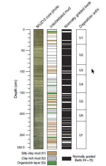
Based on geochemical analysis and organic matter content established using loss on ignition and reflectance spectroscopy, we identified six periods of increased glacial activity over the last 1700 yr. Each is in accordance with records from reference glaciers in the Alps. A total of 255 graded layers were identified and interpreted as flood deposits. Most of these occurred during glacial advances such as the Little Ice Age period and exhibit thicker deposits characterized by an increase in the fine grain-size fraction. Fine sediment produced by glacial activity is transported to the proglacial lake during heavy rainfall events. The excess of glacial flour during these periods seems to increase the watershed's tendency to produce flood deposits in the lake sediment, suggesting a strong influence of the glacier on flood reconstruction records. Thus, both flood frequency and intensity, which is estimated based on layer thickness as a proxy, cannot be used in reconstruction of past extreme events because of their variability. There is a need to take into account changes in sediment supply in proglacial areas that could preclude satisfactory interpretation of floods in terms of past climate variability.
Glacial fluctuations
Glacial focal spot
LTER - ZA - RZA
Zone Atelier Alpes
ZAA
Simple
- Date ( Revision )
- 2020-08-27T09:20:49
- Date ( Creation )
- 2015-08-19T00:00:00
- Edition
-
1.0
- Edition date
- 2020-08-27
- Identifier
-
MUZ_345e4a80-950c-4854-adde-283e60a4b962
- Status
- Completed
GRID-Arendal - A Centre Collaborating with UN Environment
-Fouinat
GRID-Arendal,P.O. Box 183 ,N-4802 Arendal, Norway Norway
,Arendal
,N-4836
,Norway
EDYTEM - UMR5204 - Environnements DYnamiques et TErritoires de la Montagne
-Pignol
Université de Savoie,ScEM,laboratoire EDYTEM France
,Le Bourget du Lac
,73376
,France
Parc National des Écrins
-Sagot
Parc national des Écrins, Domaine de Charance France
,Gap
,05000
,France
- Maintenance and update frequency
- Not planned
- GEMET - INSPIRE themes, version 1.0 GEMET - INSPIRE themes, version 1.0 ( Theme )
- GEMET GEMET ( Theme )
- Keywords ( Theme )
-
-
EnvThes (lake sediment --- http://vocabs.lter-europe.net/edg/tbl/EnvThes.editor#http%3A%2F%2Fvocabs.lter-europe.net%2FEnvThes%2F20901;environmental analysis--- http://vocabs.lter-europe.net/edg/tbl/EnvThes.editor#http%3A%2F%2Fvocabs.lter-europe.net%2FEnvThes%2F20209 )
-
LTER - ZA - RZA
-
Zone Atelier Alpes
-
ZAA
-
- Use limitation
-
This work is licensed under a Creative Commons Attribution 4.0 License (CC BY SA 4.0, https://creativecommons.org/licenses/by-sa/4.0/ ).
- Access constraints
- Copyright
- Access constraints
- License
- Use constraints
- Copyright
- Use constraints
- License
- Spatial representation type
- Text, table
- Metadata language
- Françaisfr
- Character set
- UTF8
- Topic category
-
- Environment
- Geoscientific information
- Inland waters
))
- Begin date
- 2015-08-19T00:00:00+02:00
- End date
- 2015-08-19T00:00:01
- Reference system identifier
-
EPSG
/2154
- Distribution format
-
-
mapDigital
(v1.1
)
-
- OnLine resource
-
Lac de la Muzelle
(
WWW:LINK-1.0-http--link
)Description du lac de la Muzelle sur le site internet du réseau Lacs Sentinelles : caractéristiques du lac et de son bassin versant
- OnLine resource
-
PANGEA
(
WWW:LINK-1.0-http--link
)Data Publisher for Earth & Environmental Science
- OnLine resource
-
Quaternary Research
(
WWW:LINK-1.0-http--link
)Publication scientifique
- OnLine resource
-
https://drive.google.com/drive/folders/0B9Mvho1ldur0YjR1Uk43NW01T3c
(
WWW:LINK-1.0-http--link
)
- OnLine resource
-
Cyber Carothèque Nationale
(
WWW:LINK-1.0-http--link
)
- OnLine resource
-
https://app.geosamples.org/sample/igsn/IEFRA00A4&header=1
(
WWW:LINK-1.0-http--link
)
- OnLine resource
-
Visualiseur des Zones Ateliers - LTER-France
(
WWW:LINK-1.0-http--link
)
- Hierarchy level
- Dataset
Conformance result
- Date ( Publication )
- 2010-12-08T12:00:00
- Explanation
-
See the referenced specification
- Pass
- Yes
Conformance result
- Date ( Publication )
- 2008-12-03T12:00:00
- Explanation
-
See the referenced specification
- Pass
- Yes
- Statement
-
In April 2012, cores were retrieved from the deepest part of Lake Muzelle using a UWITECH piston corer with hammer action. The master core sequence (MUZ12 / IGSN:IEFRA00A4) is composed of two coring holes. MUZ1201 – (IGSN: IEFRA094Y / IEFRA094Z) was retrieved from the lake bottom with a 90-mm-diameter tube, and MUZ1202 was retrieved with a 63-mm tube. A short gravity core, MUZ12P5 (IGSN : IEFRA00A2), was also taken to provide a well-preserved sample of the water–sediment interface.
In June 2014, a set of nine short gravity cores (MUZ14P1 to MUZ14P9) distributed across the deep portion of the lake basin were retrieved using a UWITECH piston corer, allowing us to better understand sediment partitioning throughout the entire lake system.
All cores were split in half lengthwise and archived with the intention of reusability in other projects.
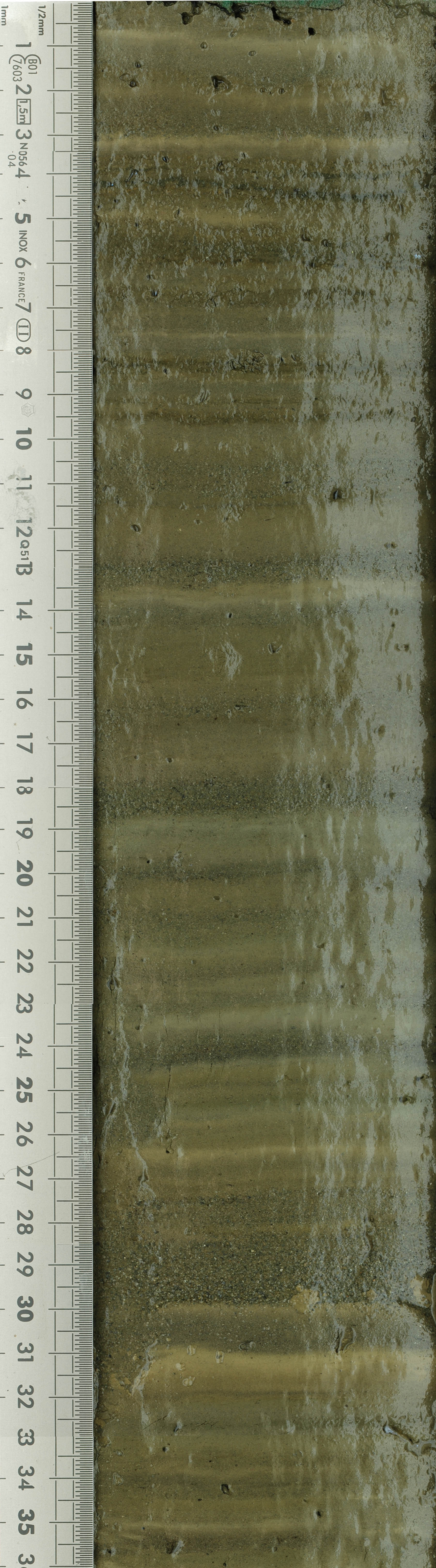
A detailed macroscopic description allowed to determine the different sedimentary facies and to establish the stratigraphic correlations between cores. A composite core was built using clearly identifiable layers in the overlapping sections of cores MUZ1201 and MUZ1202 to obtain a 283.5-cm-long sediment sequence.
The sediment sequence chronology is based on ten 14C measures on terrestrial marco-remains, short-lasting radionuclides measures and secular paleomagnetic fluctuations. 14C measures were carried out using an Accelerator Mass Spectrometry (AMS).
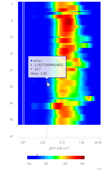
Granulometry :
Malvern 800 / samplingreésolution 1cm / Spectrum from 0_06 to 878_67 micron
Malverne 2000 (ISTERRE)/ / Sampling resolution 1cm / Spectrum frome 0_06 to 2000 micron (ech 01AW-Depth 137 to 149cm)
- File identifier
- MUZ_345e4a80-950c-4854-adde-283e60a4b962 XML
- Metadata language
- Françaisfr
- Character set
- UTF8
- Parent identifier
-
Lake Muzelle – 2105 m - Ecrins national Park - Core Muz12-I - 2017
MUZ_cf1c089d-0d41-4a24-98cc-1f527cf7d6d5
- Hierarchy level
- Dataset
- Date stamp
- 2024-10-23T16:38:48
- Metadata standard name
-
ISO 19115:2003/19139
- Metadata standard version
-
1.0
GRID-Arendal - A Centre Collaborating with UN Environment
-Fouinat
GRID-Arendal,P.O. Box 183 ,N-4802 Arendal, Norway Norway
,Arendal
,N-4836
,Norway
EDYTEM - UMR5204 - Environnements DYnamiques et TErritoires de la Montagne
-Pignol
Université de Savoie,ScEM,laboratoire EDYTEM France
,Le Bourget du Lac
,73376
,France
Parc National des Écrins
-Sagot
Parc national des Écrins, Domaine de Charance France
,Gap
,05000
,France
- Dataset URI
-
SIG
Overviews
Spatial extent
Provided by