Lake Muzelle – 2105 m - Ecrins national Park - Core Muz12-I - 2017
Local glacial fluctuations and flood occurrences were investigated in the sediment sequence of proglacial Lake Muzelle - Ecrins national Park - Composite sequence Muz12-I - april 2012 (IGSN:IEFRA00A4). Field mission 04 october 2012 (Mission "THESE FOUINAT MUZELLE L10/04/2012").
Project "THESE 2 ALPES PN ECRINS". Head of mission Pierre Sabatier
The sequence covers the period from year 303 to 2012.
Roman era to contemporary era.
Glacial fluctuation
LTER - ZA - RZA
Zone Atelier Alpes
ZAA
Simple
- Date ( Revision )
- 2020-08-27T09:20:51
- Date ( Creation )
- 2015-08-19T00:00:00
- Edition
-
1.0
- Edition date
- 2020-08-27
- Identifier
-
MUZ_cf1c089d-0d41-4a24-98cc-1f527cf7d6d5
- Status
- Completed
GRID-Arendal - A Centre Collaborating with UN Environment
-Fouinat
GRID-Arendal,P.O. Box 183 ,N-4802 Arendal, Norway Norway
,Arendal
,N-4836
,Norway
EDYTEM - UMR5204 - Environnements DYnamiques et TErritoires de la Montagne
-Pignol
Université de Savoie,ScEM,laboratoire EDYTEM France
,Le Bourget du Lac
,73376
,France
Parc National des Écrins
-Sagot
Parc national des Écrins, Domaine de Charance France
,Gap
,05000
,France
- Maintenance and update frequency
- Not planned
- GEMET - INSPIRE themes, version 1.0 GEMET - INSPIRE themes, version 1.0 ( Theme )
- GEMET GEMET ( Theme )
- Keywords ( Theme )
-
-
EnvThes (lake sediment --- http://vocabs.lter-europe.net/edg/tbl/EnvThes.editor#http%3A%2F%2Fvocabs.lter-europe.net%2FEnvThes%2F20901;environmental analysis--- http://vocabs.lter-europe.net/edg/tbl/EnvThes.editor#http%3A%2F%2Fvocabs.lter-europe.net%2FEnvThes%2F20209 )
-
LTER - ZA - RZA
-
Zone Atelier Alpes
-
ZAA
-
- Use limitation
-
This work is licensed under a Creative Commons Attribution 4.0 License (CC BY SA 4.0, https://creativecommons.org/licenses/by-sa/4.0/ ).
- Access constraints
- Copyright
- Access constraints
- License
- Use constraints
- Copyright
- Use constraints
- License
- Spatial representation type
- Vector
- Metadata language
- Françaisfr
- Character set
- UTF8
- Topic category
-
- Environment
- Geoscientific information
- Inland waters
))
- Begin date
- 2015-08-19T00:00:00+02:00
- End date
- 2015-08-19T00:00:01
- Reference system identifier
-
EPSG
/2154
- Distribution format
-
-
mapDigital
(v1.1
)
-
- OnLine resource
-
Cyber Carothèque Nationale - station MUZ12-I
(
WWW:LINK-1.0-http--link
)Informations sur le site et la mission de carottage.
- OnLine resource
-
Lac de la Muzelle
(
WWW:LINK-1.0-http--link
)Description du Lac de la Muzelle sur le site Lacs-sentinelles.org : caractéristiques du lac et de son bassin versant.
- OnLine resource
-
Adresse IGSN de la carotte
(
WWW:LINK-1.0-http--link
)
- OnLine resource
-
http://ccwbvps18.in2p3.fr/maps/visualiseur-coyoxhup#project
(
WWW:LINK-1.0-http--link
)
- OnLine resource
-
Rapport de mission du carottage du lac de la Muzelle - 10 avril 2012
(
WWW:DOWNLOAD-1.0-http--download
)
- Hierarchy level
- Dataset
Conformance result
- Date ( Publication )
- 2010-12-08T12:00:00
- Explanation
-
See the referenced specification
- Pass
- Yes
Conformance result
- Date ( Publication )
- 2008-12-03T12:00:00
- Explanation
-
See the referenced specification
- Pass
- Yes
- Statement
-
In April 2012, cores were retrieved from the deepest part of Lake Muzelle using a UWITECH piston corer with hammer action. The master core sequence (MUZ12 / IGSN:IEFRA00A4) is composed of two coring holes. MUZ1201 was retrieved from the lake bottom with a 90-mm-diameter tube, and MUZ1202 was retrieved with a 63-mm tube. A short gravity core, MUZ12P5 (IGSN : IEFRA00A2), was also taken to provide a well-preserved sample of the water–sediment interface.
In June 2014, a set of nine short gravity cores (MUZ14P1 to MUZ14P9) distributed across the deep portion of the lake basin were retrieved using a UWITECH piston corer, allowing us to better understand sediment partitioning throughout the entire lake system.
All cores were split in half lengthwise and archived with the intention of reusability in other projects.
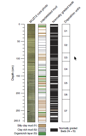
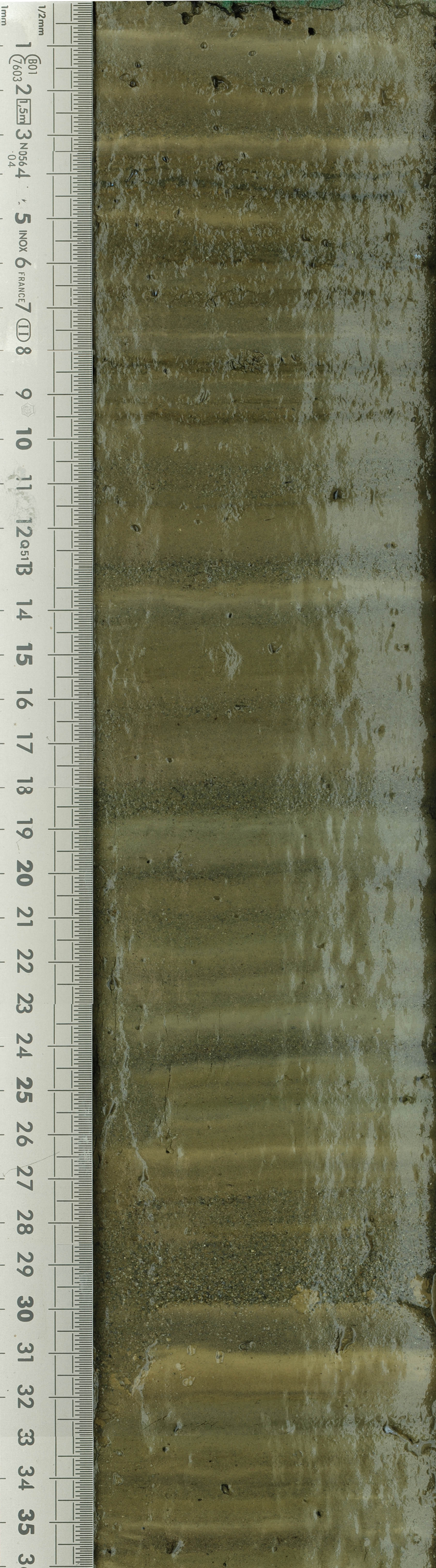
A detailed macroscopic description allowed to determine the different sedimentary facies and to establish the stratigraphic correlations between cores. A composite core was built using clearly identifiable layers in the overlapping sections of cores MUZ1201 and MUZ1202 to obtain a 283.5-cm-long sediment sequence.
- File identifier
- MUZ_cf1c089d-0d41-4a24-98cc-1f527cf7d6d5 XML
- Metadata language
- Françaisfr
- Character set
- UTF8
- Hierarchy level
- Dataset
- Date stamp
- 2024-10-23T16:48:41
- Metadata standard name
-
ISO 19115:2003/19139
- Metadata standard version
-
1.0
GRID-Arendal - A Centre Collaborating with UN Environment
-Fouinat
GRID-Arendal,P.O. Box 183 ,N-4802 Arendal, Norway Norway
,Arendal
,N-4836
,Norway
EDYTEM - UMR5204 - Environnements DYnamiques et TErritoires de la Montagne
-Pignol
Université de Savoie,ScEM,laboratoire EDYTEM France
,Le Bourget du Lac
,73376
,France
Parc National des Écrins
-Sagot
Parc national des Écrins, Domaine de Charance France
,Gap
,05000
,France
- Dataset URI
-
Parent
Overviews
Spatial extent
Provided by