 Catalogues des Parcs Nationaux
Type of resources
Available actions
Topics
INSPIRE themes
Keywords
Contact for the resource
Provided by
Years
Formats
Representation types
Update frequencies
status
Scale
-
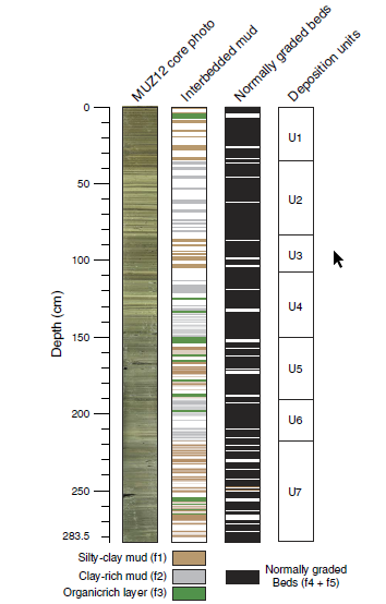
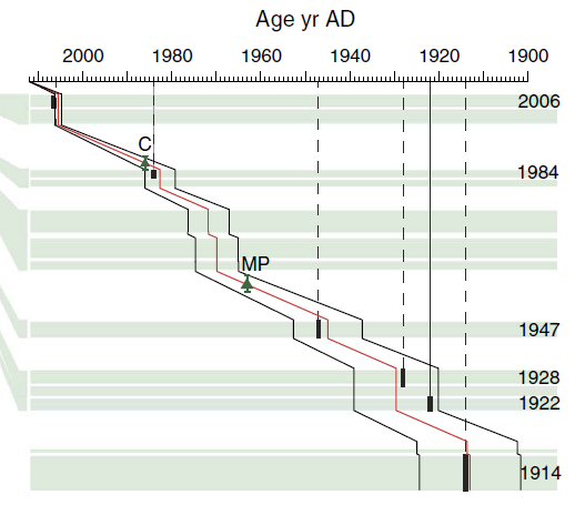
Local glacial fluctuations and flood occurrences were investigated in the sediment sequence of proglacial Lake Muzelle - Ecrins national Park - Composite sequence Muz12-I - april 2012 (IGSN:IEFRA00A4). Field mission 04 october 2012 (Mission "THESE FOUINAT MUZELLE L10/04/2012"). Project "THESE 2 ALPES PN ECRINS". Head of mission Pierre Sabatier The sequence covers the period from year 303 to 2012. Roman era to contemporary era. Glacial fluctuation LTER - ZA - RZA Zone Atelier Alpes ZAA
-

Ensemble des lignes de lecture du PNE. SOURCE : Olivier SENN, relevés des 2 extrémités au GPS en 2008. 2017-01-23 - MAJ avec ajout de la ligne 132 (Le Lauzet)
-
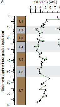
Local glacial fluctuations and flood occurrences were investigated in the sediment sequence of proglacial Lake Muzelle. The sample covers the period from 303 to 2012. Loss On Ignition (LOI) 2017 Based on geochemical analysis and organic matter content established using loss on ignition and reflectance spectroscopy, we identified six periods of increased glacial activity over the last 1700 yr. Each is in accordance with records from reference glaciers in the Alps. A total of 255 graded layers were identified and interpreted as flood deposits. Most of these occurred during glacial advances such as the Little Ice Age period and exhibit thicker deposits characterized by an increase in the fine grain-size fraction. Fine sediment produced by glacial activity is transported to the proglacial lake during heavy rainfall events. The excess of glacial flour during these periods seems to increase the watershed's tendency to produce flood deposits in the lake sediment, suggesting a strong influence of the glacier on flood reconstruction records. Thus, both flood frequency and intensity, which is estimated based on layer thickness as a proxy, cannot be used in reconstruction of past extreme events because of their variability. There is a need to take into account changes in sediment supply in proglacial areas that could preclude satisfactory interpretation of floods in terms of past climate variability. Glacial fluctuations Glacial focal spot LTER - ZA - RZA Zone Atelier Alpes ZAA
-
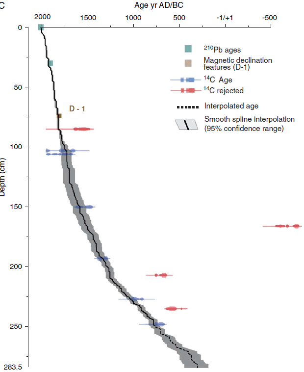
Local glacial fluctuations and flood occurrences were investigated in the sediment sequence of proglacial Lake Muzelle - Ecrins National Park - Composite sediment sequence Muz12-I - april 2012 - (IGSN:IEFRA00A4). The sample covers the period from 303 to 2012. Based on geochemical analysis and organic matter content established using loss on ignition and reflectance spectroscopy, we identified six periods of increased glacial activity over the last 1700 yr. Each is in accordance with records from reference glaciers in the Alps. A total of 255 graded layers were identified and interpreted as flood deposits. Most of these occurred during glacial advances such as the Little Ice Age period and exhibit thicker deposits characterized by an increase in the fine grain-size fraction. Fine sediment produced by glacial activity is transported to the proglacial lake during heavy rainfall events. The excess of glacial flour during these periods seems to increase the watershed's tendency to produce flood deposits in the lake sediment, suggesting a strong influence of the glacier on flood reconstruction records. Thus, both flood frequency and intensity, which is estimated based on layer thickness as a proxy, cannot be used in reconstruction of past extreme events because of their variability. There is a need to take into account changes in sediment supply in proglacial areas that could preclude satisfactory interpretation of floods in terms of past climate variability. LTER - ZA - RZA Zone Atelier Alpes ZAA
-
Local glacial fluctuations and flood occurrences were investigated in the sediment sequence of proglacial Lake Muzelle. Composite sediment sequence Muz12-I – april 2012 (IGSN:IEFRA00A4). The sample covers the period from 303 to 2012. Based on geochemical analysis and organic matter content established using loss on ignition and reflectance spectroscopy, we identified six periods of increased glacial activity over the last 1700 yr. Each is in accordance with records from reference glaciers in the Alps. A total of 255 graded layers were identified and interpreted as flood deposits. Most of these occurred during glacial advances such as the Little Ice Age period and exhibit thicker deposits characterized by an increase in the fine grain-size fraction. Fine sediment produced by glacial activity is transported to the proglacial lake during heavy rainfall events. The excess of glacial flour during these periods seems to increase the watershed's tendency to produce flood deposits in the lake sediment, suggesting a strong influence of the glacier on flood reconstruction records. Thus, both flood frequency and intensity, which are estimated based on layer thickness as a proxy, cannot be used in reconstruction of past extreme events because of their variability. There is a need to take into account changes in sediment supply in proglacial areas that could preclude satisfactory interpretation of floods in terms of past climate variability. Glacial fluctuation Glacial focal spot LTER - ZA - RZA Zone Atelier Alpes ZAA
-
-
-
Synthèse des observations de faune et de flore réalisées par les agents du Parc national des Ecrins depuis sa création en 1973. Mise à jour continue à partir des différents protocoles d'inventaire et de suivi de la faune et de la flore. Cette synthèse agglomère l'ensemble des observations depuis différents protocoles, en ne gardant que leur tronc commun (Observateurs / Date / Taxon - espèce, basé sur le référence national Taxref du MNHN / Localisation XY / Altitude / Protocole source / Jeu de données / Commune / Organisme producteur de la donnée / Critère d'observation).
-
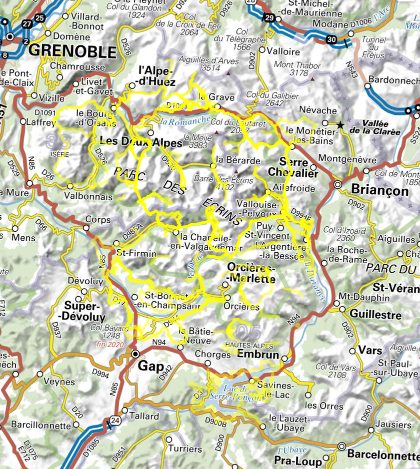
Randonnées estivales du Parc national des Écrins (Hautes-Alpes et Isère). Les champs de ce jeu de données sont conformes à la première version du schéma de données pour les randonnées en cours d'élaboration. Ce schéma favorise les échanges de données entre structures productrices et utilisatrices (communautés de communes, parcs naturels, départements, offices de tourisme...). La construction de ce schéma de randonnée est collaborative, vous pourrez trouver toutes les informations liées à son avancée sur ce dépôt : https://github.com/PnX-SI/schema_randonnee.
-