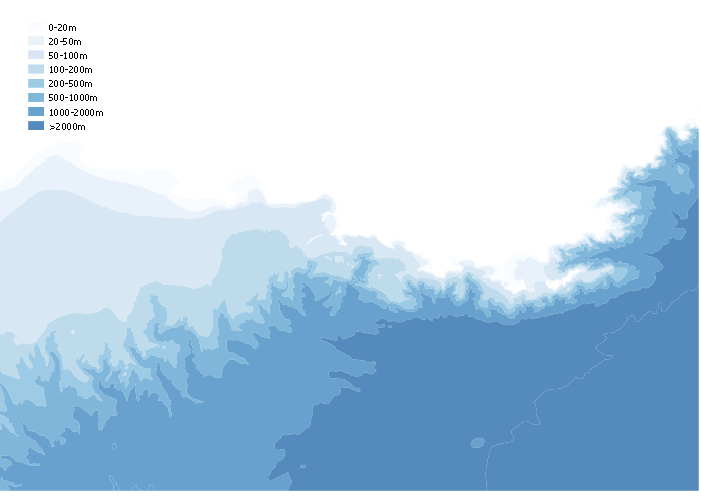
Bathymétrie du Parc national de Port-Cros
Relevé des profondeurs du fond marin de l'Aire Maritime Adjacente du Parc national de Port-Cros. La valeur est exprimé en côte marine (mètres) et à pour référence le zéro hydrographique.
Simple
- Date ( Creation )
- 2017-05-22
- Identifier
- FR-2018-JFUGiEarxdKt_112217H19M35S
- Status
- Completed
Point of contact
Parc national de Port-Cros
181 Allée du Castel Sainte Claire BP 70220
,
Hyères
,
83406
,
France
0494128914
- GEMET - INSPIRE Themes
-
- Altitude
- Keywords ( Place )
-
- Parc national de Port-Cros
- Keywords ( Theme )
-
- bathymétrie
- Keywords ( Theme )
-
- Référentiel
- Use limitation
- Utilisation libre sous réserve de mentionner la source (PNPC)
- Access constraints
- Other restrictions
- Other constraints
- Pas de restriction d'accès public selon INSPIRE
- Spatial representation type
- Vector
- Denominator
- 25000
- Metadata language
- fr
- Character set
- UTF8
- Topic category
-
- Elevation
- Description
- Liste des emprises
N
S
E
W
))
- Reference system identifier
- RGF93 / Lambert-93 / 2154 / 6.11
- Topology level
- Abstract
- Geometric object type
- Surface
- Distribution format
-
-
ESRI Shapefile
(
1.0
)
-
ESRI Shapefile
(
1.0
)
- OnLine resource
- Nom de la couche en interne : PNPC_habillage_bathy
- OnLine resource
-
PNPC_habillage_bathy
(
WWW:DOWNLOAD-1.0-http--download
)
Fichier .shp de la bathymétrie du Parc national de Port-Cros
- Hierarchy level
- Dataset
Conformance result
- Date ( Creation )
- 2010-11-23
- Explanation
- See the referenced specification
- Pass
- Yes
- File identifier
- FR-2018-JFUGiEarxdKt_112217H19M35S XML
- Metadata language
- fr
- Character set
- UTF8
- Hierarchy level
- Dataset
- Date stamp
- 2019-02-28T18:18:40
- Metadata standard name
- ISO19115
- Metadata standard version
- 2003/Cor.1:2006
Point of contact
Parc national de Port-Cros
181 Allée du Castel Sainte Claire BP 70220
,
Hyères
,
83406
,
France
0494128914
Overviews

Bathymétrie du Parc national de Port-Cros
Spatial extent
N
S
E
W
))
Provided by

Associated resources
Not available
 Catalogues des Parcs Nationaux