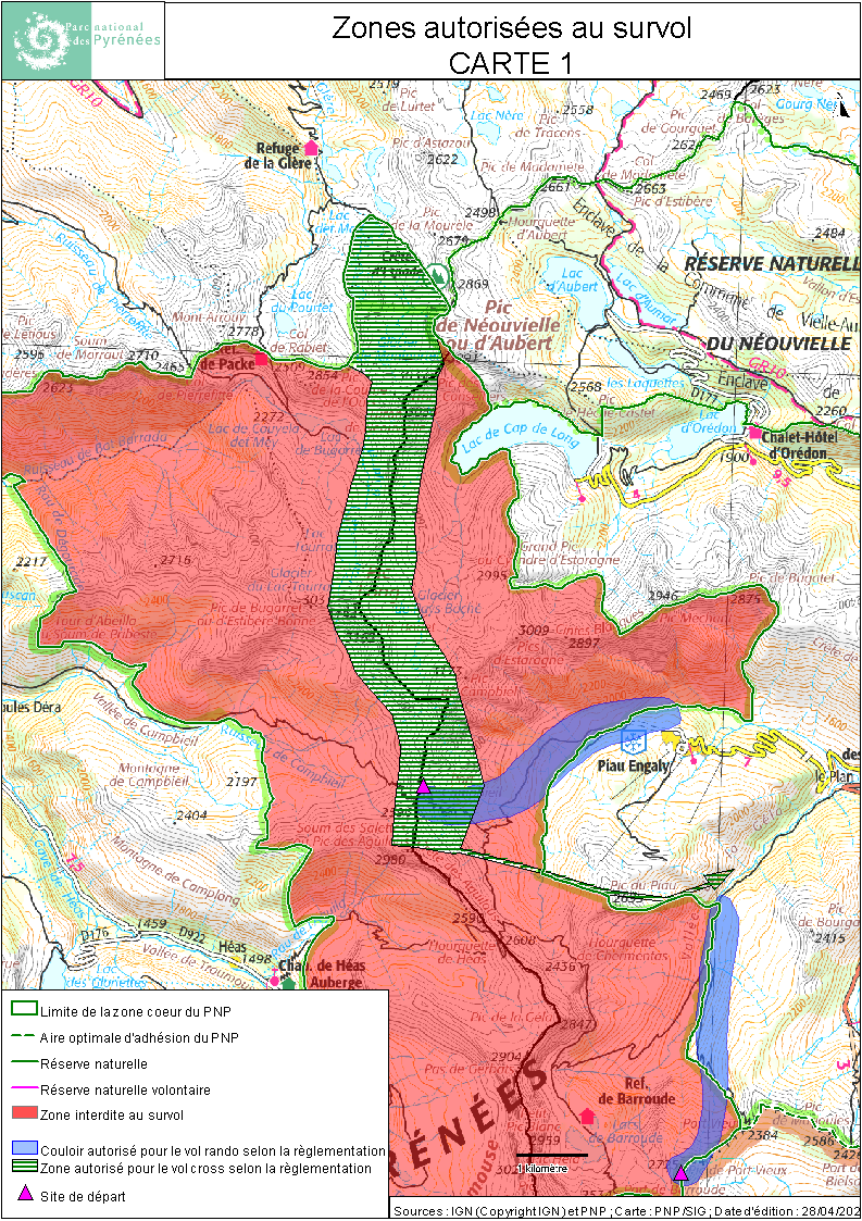
Carte des zones autorisées au survol (vol libre) Aure Luz (Carte 1)
Cette carte représente, sur les vallées d'Aure et de Luz, les zones de survol autorisés pour le vol libre en zone coeur du Parc national des Pyrénées par arrêté du directeur.
Donnée publique. Cette carte peut être utilisée sous réserve de préciser l'auteur : Parc national des Pyrénées/SIG
Simple
- Date ( Publication )
- 2022
- Presentation form
- Digital map
- Credit
-
Parc national des Pyrénées
- Keywords ( Theme )
-
-
Parc national des Pyrénées
-
- Metadata language
- fr
- Topic category
-
- Environment
N
S
E
W
))
- Reference system identifier
-
Lambert 93
- Distribution format
-
-
PDF
(1.7
)
-
- OnLine resource
-
https://catalogue.parcnational.fr/catalogue/pnp/api/records/d8d16297-e7c3-42a9-8071-e51e363b353a/attachments/Carte1_2021.zip
(
WWW:DOWNLOAD-1.0-http--download
)
- File identifier
- d8d16297-e7c3-42a9-8071-e51e363b353a XML
- Metadata language
- fr
- Character set
- UTF8
- Hierarchy level
- Map
- Date stamp
- 2022-05-05T16:16:31
- Metadata standard name
-
ISO 19115:2003/19139
- Metadata standard version
-
1.0
- Dataset URI
-
Documents\documents internes\travaux service\THEMES\survol\survol vol libre\cartes definitives\2021-2022\Carte1 - DEF.wor
Overviews
Spatial extent
N
S
E
W
Provided by
Associated resources
Not available