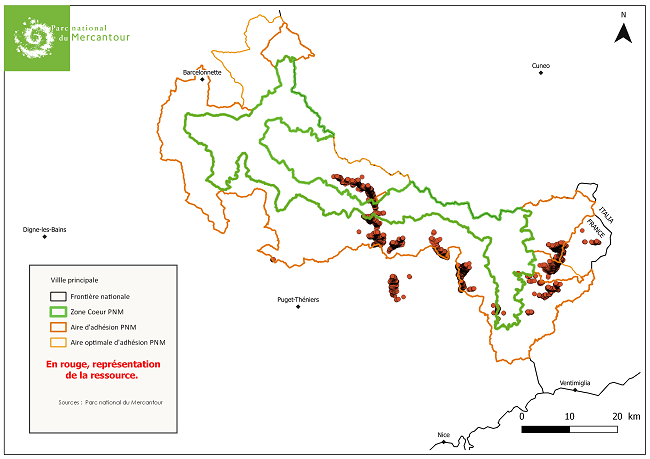
Chataigneraies probables Parc National du Mercantour (06)
Localisation des châtaigniers
Simple
- Date ( Revision )
- 2016-05-08
- Date ( Creation )
- 2012-12-01
- Date ( Publication )
- 2018-07-13
- Identifier
- chataigneraie.chataigneraie_probable
- Name
- ESRI Shapefile
- Version
- 1.0
- Keywords ( Theme )
-
- châtaigniers
- arboriculture
- Châtaigneraie
- GEMET - INSPIRE themes, version 1.0 ( Theme )
-
- Occupation des terres
- GEMET ( Theme )
-
- agriculture
- Classification
- Unclassified
- Use limitation
- Aucune condition ne s’applique
- Access constraints
- Other restrictions
- Use constraints
- Other restrictions
- Other constraints
- pas de restriction d'accès public
- Denominator
- 500
- Metadata language
- fr
- Topic category
-
- Farming
N
S
E
W
))
- Begin date
- 2009-01-01
- End date
- 2016-05-08
- Reference system identifier
- EPSG / RGF93 / Lambert-93 (EPSG:2154) / 7.4
- Geometric object type
- Point
- Distribution format
-
-
ESRI Shapefile
(
1.0
)
-
ESRI Shapefile
(
1.0
)
- OnLine resource
- http://www.mercantour-parcnational.fr/fr
- OnLine resource
-
chataignier_probable_pnm_06
(
WWW:DOWNLOAD-1.0-http--download
)
Téléchargez ici le fichier chataignier_probable_pnm_06 au format shp.
- Statement
- Les points représentent les châtaigniers identifiés individuellement à l'échelle du 1/500 ( un pour cinq cents) sur photographies aeriennes couleur IGN 2009. Des contrôles terrain ont été effectués entre 2011 et 2013. Marge d'erreur en raison de la difficulté à distinguer les châtaigniers sains des autres feuillus: 10 à 20%. Equipe de réalisation: Jean-Marie Castex, Mohamed Ben Jeddou, Eric Bailly,Gourguen Davtian, Eric Gili, Isabelle Mor.
- File identifier
- 0631aea4-4fce-4dd1-a372-513fa2f7da1d XML
- Metadata language
- fr
- Hierarchy level
- Dataset
- Date stamp
- 2019-02-08T10:56:51
Overviews

Chataigniers probables (06)
Spatial extent
N
S
E
W
))
Provided by

Associated resources
Not available
 Catalogues des Parcs Nationaux