 Catalogues des Parcs Nationaux
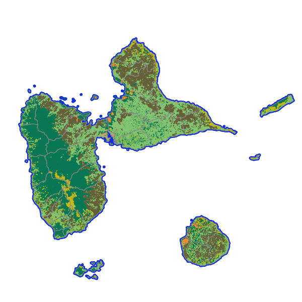
KaruCover: le référentiel d'occupation des sols à grande échelle en 2D
KaruCover est le référentiel cartographique d'occupation du sol en 2 dimensions du territoire guadeloupéen pour les années 2010 et 2017. Il qualifie les différents types d'espaces (urbain, agricole et naturel) selon deux dimensions (le couvert du sol et l'usage du sol) et permet de suivre les dynamiques territoriales. Le couvert du sol est une vue physionomique du terrain (forêt, bâti...). L'usage du sol (ou la fonction) est une vue anthropique (habitat, activités...). L'occupation du sol en deux dimensions KaruCover 2017 est le référentiel pour l'année 2017. Le produit répond aux standard "OCSGE" du Conseil National de l'Information Géographique (CNIG).
Simple
Identification info
Contains Operations
- Operation Name
- Accès à la métadonnée de service WMS
- Distributed Computing Platforms
- Web services
- Connect Point
- https://catalogue.karugeo.fr/geonetwork/srv/fre/catalog.search#/metadata/96916365-fc7b-4a0a-ab39-aeea91c7c7c4 ( WWW:LINK-1.0-http--link )
- Date ( Publication )
- 2021-04-18
- INSPIRE Service taxonomy ( Theme )
-
- infoMapAccessService
- Keywords
-
- Access constraints
- License
- Use constraints
- License
- Other constraints
- Licence ouverte 2.0
- Classification
- Unclassified
- Service Type
- invoke
- Description
- Guadeloupe
N
S
E
W
))
- Coupling Type
- Tight
Contains Operations
- Operation Name
- Accès au fichier contexte OWS de la carte
- Distributed Computing Platforms
- Web services
Contains Operations
- Operation Name
- Accès à la carte interactive
- Distributed Computing Platforms
- Web services
- Connect Point
- https://catalogue.karugeo.fr/geosource/consultation?id=21419576 ( WWW:LINK-1.0-http--link )
Contains Operations
- Operation Name
- Accès au fichier contexte OWS de la carte
- Distributed Computing Platforms
- Web services
- Connect Point
- https://carto.karugeo.fr/context/getOws/21419576 ( WWW:LINK-1.0-http--link )
Contains Operations
- Operation Name
- Accès à la carte interactive
- Distributed Computing Platforms
- Web services
- Connect Point
- https://catalogue.karugeo.fr/geosource/consultation?id=21419576 ( WWW:LINK-1.0-http--link )
Coupled Resource
- Operation Name
- GetCapabilities
- Identifier
- d093a67f-d9d4-4b47-af19-42ef49b87cd8
Coupled Resource
- Operation Name
- GetCapabilities
- Identifier
- 0bc2aeb1-55e4-4f19-a164-10a892395152
Coupled Resource
- Operation Name
- GetCapabilities
- Identifier
- 0c26ff2e-4a88-4ef0-9462-8a7ca37f35d4
Coupled Resource
- Operation Name
- GetCapabilities
- Identifier
- 8d414463-5ed7-4629-9db5-277878b4b50f
- Reference system identifier
- EPSG / WGS 84 / UTM zone 20N (EPSG:32620) / 7.9
- OnLine resource
- Accès à la métadonnée de service ( WWW:LINK-1.0-http--link )
- Units of distribution
- liens associés
- OnLine resource
-
Accès à la carte
(
WWW:LINK-1.0-http--link
)
Accès à la carte
- OnLine resource
-
Accès au fichier contexte OWS de la carte
(
WWW:LINK-1.0-http--link
)
Accès au fichier contexte OWS de la carte
- OnLine resource
-
Accès au fichier PDF de la carte
(
WWW:LINK-1.0-http--link
)
Accès au fichier PDF de la carte
- File identifier
- 685a038a-ae1f-4152-8e69-f87ba4cad92f XML
- Metadata language
- fre
- Character set
- UTF8
- Hierarchy level
- Service
- Hierarchy level name
- service
- Date stamp
- 2021-04-19T18:10:54
- Metadata standard name
- ISO 19115:2003/19139
- Metadata standard version
- 1.0
Overviews
Aperçu
Spatial extent
N
S
E
W
Provided by

Associated resources
Not available