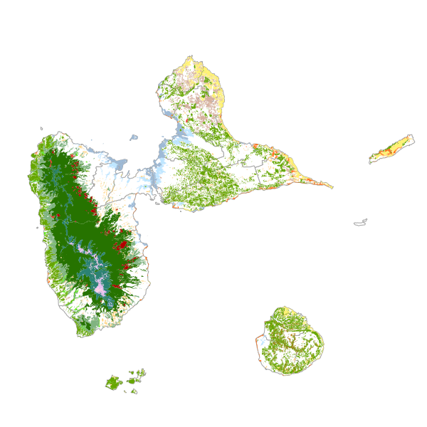
Diagnostic forestier - formations végétales de Guadeloupe 1950
La cartographie des formations végétales guadeloupéenne identifie et localise les espaces naturels ou semi-naturels de l'archipel (exception faite de Saint-Barthélemy, Saint-Martin et Petite-Terre). 17 types de milieux naturels ont été identifiés, dont 11 répondent à la définition internationale de la forêt.
Simple
- Date ( Revision )
- 2019-01-13T22:26:49
- Date ( Creation )
- 2014-01-26
- GEMET - INSPIRE themes, version 1.0 ( Theme )
-
-
Occupation des terres
-
- Keywords ( Theme )
-
-
Flore et faune
-
Occupation des sols
-
Habitats et biotopes
-
Formations végétales
-
- Régions de France ( Place )
-
-
GUADELOUPE
-
- theme.prodige.rdf ( Theme )
-
-
Conseil Général
-
FORET
-
Acteurs Institutionnels
-
OCCUPATION DU SOL
-
- Keywords
-
- Access constraints
- Intellectual property rights
- Use limitation
-
Utilisation libre sous réserve de mentionner la source (a minima le nom du producteur) et la date de sa dernière mise à jour
- Spatial representation type
- Vector
- Denominator
- 50000
- Metadata language
-
fre
- Topic category
-
- Biota
- Environment
))
- Begin date
- 1950-01-01
- Reference system identifier
-
EPSG
/WGS 84 / UTM zone 20N (EPSG:32620)
/8.6
- Distribution format
-
-
ZIP
( )
-
- OnLine resource
-
formation_vegetale_1950
(
OGC:WMS-1.1.1-http-get-map
)
- Hierarchy level
- Dataset
Conformance result
- Date ( Publication )
- 1999-12-05
- Explanation
-
cf. la spécification citée
- Pass
- Yes
- Statement
-
La cartographie des formations végétales de 1950 a été produite par photo-interprétation des ortho-photos de l'IFREMER de 1950 et par comparaison avec la cartographie des formations végétales de 2010 de l'IGN.
- Feature catalogue citation
- File identifier
- 2eb814a3-1528-496a-935c-0f064e737229 XML
- Metadata language
- fr
- Character set
- UTF8
- Hierarchy level
- Dataset
- Hierarchy level name
-
Série de données
- Date stamp
- 2024-03-13T10:09:27
- Metadata standard name
-
ISO 19115:2003/19139
- Metadata standard version
-
1.0
Overviews
Spatial extent
Provided by