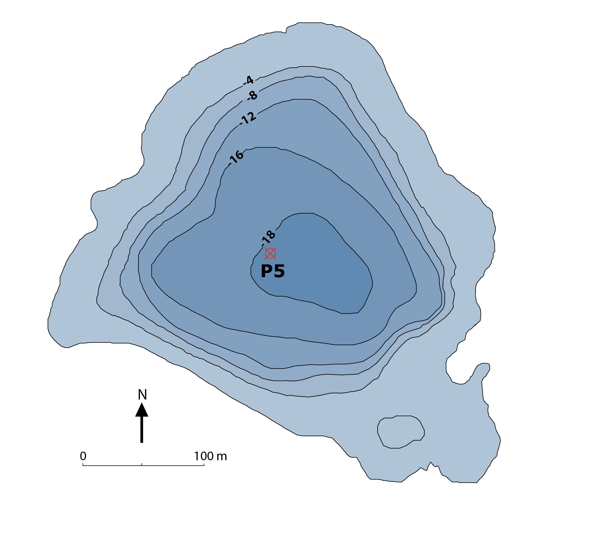
Lake Muzelle – Bathymetry (grid data) – 2016
Mountain lakes are often situated in protected natural areas, a feature that leads to their role as sentinels of global environmental change. The data contain the grid data of bathymetry measured in Lake Muzelle in the Massif des Ecrins (WGS 84).
LTER - ZA - RZA
Zone Atelier Alpes
ZAA
Simple
- Date ( Revision )
- 2020-08-13T14:26:24
- Date ( Creation )
- 2020-07-10T00:00:00
- Edition
-
1.0
- Edition date
- 2020-08-13
- Identifier
-
MUZ_8a2fa252-0130-4ec2-b990-4c905588431f
- Status
- Completed
EDYTEM - UMR5204 - Environnements DYnamiques et TErritoires de la Montagne
-Pignol
Université de Savoie,ScEM,laboratoire EDYTEM France
,Le Bourget du Lac
,73376
,France
- Maintenance and update frequency
- Not planned
- GEMET - INSPIRE themes, version 1.0 GEMET - INSPIRE themes, version 1.0 ( Theme )
- GEMET GEMET ( Theme )
- Keywords ( Theme )
-
-
EnvThes (lake --- http://vocabs.lter-europe.net/edg/tbl/EnvThes.editor#http%3A%2F%2Fvocabs.lter-europe.net%2FEnvThes%2F10010;environmental analysis--- http://vocabs.lter-europe.net/edg/tbl/EnvThes.editor#http%3A%2F%2Fvocabs.lter-europe.net%2FEnvThes%2F20209;bathymetry---http://vocabs.lter-europe.net/edg/tbl/EnvThes.editor#http%3A%2F%2Fvocabs.lter-europe.net%2FEnvThes%2F20 315)
-
LTER - ZA - RZA
-
Zone Atelier Alpes
-
ZAA
-
- Use limitation
-
This work is licensed under a Creative Commons Attribution 4.0 License (CC BY SA 4.0, https://creativecommons.org/licenses/by-sa/4.0/ ).
- Access constraints
- Copyright
- Access constraints
- License
- Use constraints
- Copyright
- Use constraints
- License
- Spatial representation type
- Grid
- Metadata language
- Françaisfr
- Character set
- UTF8
- Topic category
-
- Inland waters
- Environment
))
- Begin date
- 2016-06-25T00:00:00+02:00
- End date
- 2016-06-25T00:00:01
- Reference system identifier
-
EPSG
/2154
- Distribution format
-
-
mapDigital
(v1.1
)
-
- Description
-
Lac de la Muzelle – Bathymétrie_Modèle_Points de mesure– 2016
- Hierarchy level
- Dataset
Conformance result
- Date ( Publication )
- 2010-12-08T12:00:00
- Explanation
-
See the referenced specification
- Pass
- Yes
Conformance result
- Date ( Publication )
- 2008-12-03T12:00:00
- Explanation
-
See the referenced specification
- Pass
- Yes
- Statement
-
In June 2016, EDYTEM laboratory carried out the complete bathymetry of Lake Muelle in the Massif des Ecrins. The bathymetry was done with a Garmin Gps traceur Sonda Echomap
The raw depth data was subsequently modelled as a gridmap (spline interoplation by Surfer Tools)
GEOGCS["GCS_WGS_1984",DATUM["D_WGS_1984",SPHEROID["WGS_1984"
- File identifier
- MUZ_8a2fa252-0130-4ec2-b990-4c905588431f XML
- Metadata language
- Françaisfr
- Character set
- UTF8
- Parent identifier
-
Lake Muzelle – Bathymetry
MUZ_1050a5ee-0ea4-4570-ae3a-e14b84e25238
- Hierarchy level
- Dataset
- Date stamp
- 2024-12-09T16:30:27
- Metadata standard name
-
ISO 19115:2003/19139
- Metadata standard version
-
1.0
EDYTEM - UMR5204 - Environnements DYnamiques et TErritoires de la Montagne
-Pignol
Université de Savoie,ScEM,laboratoire EDYTEM France
,Le Bourget du Lac
,73376
,France
Overviews
Spatial extent
Provided by