 Catalogues des Parcs Nationaux
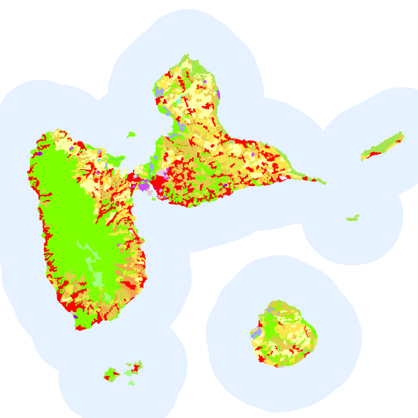
CORINE Land Cover - DOM - 2018
La base de données géographique CORINE Land Cover (CLC) est un inventaire biophysique de l'occupation des terres. Il est produit dans le cadre du programme européen d'observation de la terre Copernicus (39 États européens).
Données de référence, CORINE Land Cover est issue de l'interprétation visuelle d'images satellitaires et est disponible pour les années suivantes : 1990, 2000, 2006, 2012 et 2018. Ces bases d'état sont accompagnées par les bases des changements 1990-2000, 2000-2006 et 2006-2012 (données sur les portions du territoire ayant changé d'occupation des sols).
Simple
- Alternate title
- CLC12 European seamless vector data
- Date ( Revision )
- 2019-06-21T20:03:29
- Date
- Edition
- 02/2016
- Presentation form
- Digital map
- Keywords
-
- Downloadable Data
- Keywords
-
- Keywords
-
- Keywords
-
- Use limitation
- no conditions apply to access and use
- Other constraints
- no limitations on public access
- Spatial representation type
- Vector
- Metadata language
- en
- Character set
- UTF8
- Topic category
-
- Environment
- Environment description
- Microsoft Windows 7 Version 6.1 (Build 7601) Service Pack 1; Esri ArcGIS 10.5.0.6491
N
S
E
W
))
- Reference system identifier
- EPSG / 3035 / 7.7(10.1.0)
- Topology level
- Geometry only
- Geometric object type
- Composite
- Geometric object count
- 797
- Distribution format
-
-
File Geodatabase Feature Class
()
-
File Geodatabase Feature Class
()
Distributor
- Name
- File Geodatabase Feature Class
- Transfer size
- 6.194
- OnLine resource
- Téléchargement direct des données ( WWW:LINK-1.0-http--link )
- Distribution format
-
-
ZIP
(
)
-
ZIP
(
)
- OnLine resource
- https://catalogue.karugeo.fr/geosource/panierDownloadFrontalParametrage?LAYERIDTS=21388770 ( WWW:DOWNLOAD-1.0-http--download )
- Statement
- Vector CLC database was provided by National Teams within original CLC1990, I&CLC2000 update, FTSP/CLC2006 update, CLC2012 and CLC2018 projects. All features in original vector database were classified and digitised based on satellite images with 100 m positional accuracy (according to CLC specifications) and 25 ha minimum mapping unit into the standardized CLC nomenclature (44 CLC classes). European Corine Land Cover seamless DBs represent the final product of European data integration. The process of data integration started when national deliveries have been accepted and the Database Acceptance Report (DBTA) delivered . Delivered national data were produced in local national systems of all participating countries. The data for FR DOMs area was left in the source coordinate system. Note: Some artificial lines (dividing polygons with the same code) can be still present in database due to technical constraints of current ArcGIS technology, but has no impact for dataset contents and can be dissolved for data extracts.
- Feature catalogue citation
- File identifier
- 639ef129-a7ea-4b82-914c-945343134eda XML
- Metadata language
- en
- Character set
- UTF8
- Hierarchy level
- Dataset
- Hierarchy level name
- dataset
- Date stamp
- 2024-03-13T10:10:13
- Metadata standard name
- INSPIRE Metadata Implementing Rules: Technical Guidelines based on EN ISO 19115 and EN ISO 19119
- Metadata standard version
- V. 1.2
Point of contact
European Topic Centre on Urban, land and soil systems (ETC ULS)
-
Andreas Littkopf
Environment Agency Austria, Spittelauer Lande 5
,
Wien
,
1090
,
Overviews
Aperçu
Spatial extent
N
S
E
W
Provided by

Associated resources
Not available